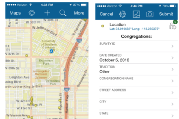
The USC Center for Religion and Civic Culture has mapped more than 500 congregations across Southern California, creating neighborhood maps that present information on congregations in a designated area. A key data collection tool that CRCC utilized in this process is a smart phone/tablet “congregational research app.”
Along with the USC Spatial Sciences Institute, CRCC customized the content of the Esri Collector for ArcGIS app so that it has an extensive menu of quantitative and qualitative data categories for collection. (The Collector app is available on the Apple App Store and the Google Play App Store.) The data query content includes information such as the name and location of the congregation, the name of the leader, details of the physical plant and an accounting of the spiritual and social programs offered through the congregation. The content also includes qualitative observations of the community and the congregation.
Below, CRCC has provided an extensive set of instructions about how to use the Collector app in your own organization and how to display the data through available “story maps.” One advantage of using the Collector app is that a significant amount of detailed congregational data can be easily collected without any interaction with congregational personnel, through direct observation and the information provided online.